Posts

Showing posts from January, 2018

Great Geology Lunch Spots No. 3: Eas Fors, near Ulva Ferry, Mull

Image
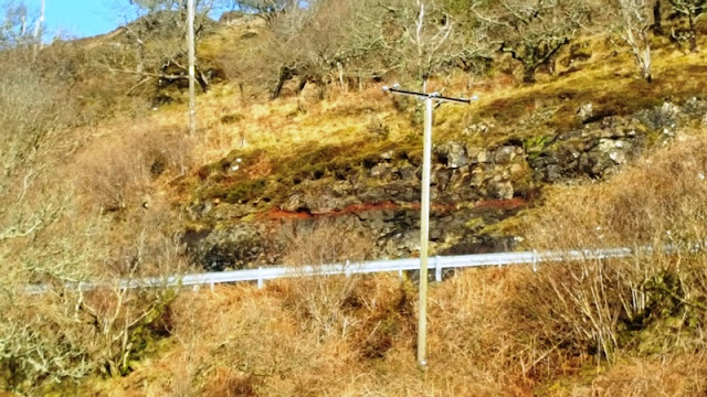
I had a visit out to Ulva Ferry today. There are loads of nice places over that way to stop for lunch and my favourite has to be the Eas Fors waterfall at Camus an Lagain just north of Lagganulva. Its easy to get to although the path was a bit soggy today. It is a great waterfall with some really interesting geology near by. Because of the amount of rain , the waterfall was fairly pouring over the edge today. Here are some photos: First up however is this view from the track looking up the cliff above the main road - there is a red bole bed in there that is very obvious and very red. It is also quite thin and forms a very distinct layer. I went for a closer look later Red bole in cliff above road Moving on to the waterfall. The rocks above are basalt lavas for the most part plus some mugearites. There is also an obvious volcanic ash at the base - this also extends out along the shore. Eas Fors in full flow Sun came out and I got a rainbow in the waterfall The cl

Great Geology Lunch Spots No.2: Garmony, Isle of Mull

Image
The Forestry Commission car park at Garmony is a great place to stop for lunch. There are excellent views over to Morvern across the Sound of Mull. There are also some interesting geological things to see on the shore. Since a picture is worth a thousand words, here are some photos from today: Looking across to Morvern, a really obvious revers fault runs through the lavas. According to the map there is also an outcrop of Carboniferous rocks on the shore near there - the most northerly Carboniferous in Britain apparently. Never been to it but looked over often enough! Looking the other way, Dun Da Ghaoithe rises above  - snow melting fast There is a sign telling you about the area (nothing about the geology though!) Walking along the path takes you to Fishnish - on the way at the shore there is an outcrop of a rock that is marked on the BGS map as a "fluxion felsite". It is intruded into Lower Jurassic rocks that are part of the Craignure Anticline / Syncline

Great Geology Lunch Spots - No. 1: P-Forms near Knock

Image
Had a bit of time at lunchtime today so I headed off to one of my favourite places - the side of Loch Na Keal, just south of Knock near Scarisdale Point. Its a great viewpoint with good views up and down the loch, but importantly, it is reckoned to be one of the best places in the UK to see glacial P-forms. there is a good JNCC paper on these things with various ideas given as to their formation. You can read it at: http://jncc.defra.gov.uk/pdf/gcrdb/GCRsiteaccount1438.pdf They also look neat under heavy frost - there are obvious striae on the  P-Forms and these show up well under frost.. As well as P-forms there are also some rather impressive dykes of the Mull Swarm cutting the shore. There is a huge concentration of these things in this area (similar to Croggan in this repsect) and they are very easy to see as all this geology is right by the road!  A few pics, mainly of the P-Forms:  A particularly wind blown tree is a good location indicator - behind it is a weathered

A strange thing in the road cutting

Image
Near the highest part of the road leading from Tobermory to Salen, the area known as the Guala Dhubh, there are some impressive road cuttings which date back to when the road was upgraded. The rocks are all volcanic - Paeleogene lavas with prominent red boles in between many of them. On the west side of the road cut at Grid Ref NM 53306 51640, there is an obvious cleft in the rock - it shows up on Google Streetview as well. I went to have a look at it some time ago but couldnt quite fathom it out - was it a dyke, a fault or maybe the cast of a fossil tree? I had been having some correspondence on Twitter with a PhD student who has been studying the Mull lavas and as a consequence of that I went back for another look. Pics and explanations below: The roadcut at the highest point of the Tobermory Salen road. Moira brought Geo-dog Daisy along to ensure that all was correct and in order. The cleft is the obvious feature running up the cliff, seen from the other side of t

A trip to the Rubha na Sealbhaig Dyke (Bloody Bay)

Image
Rubha na Sealbhaig lies to the north of Tobermory at the north end of Bloody Bay. There is a really neat dyke there, presumably a member of the Mull Swarm , although it runs more N-S rather than NW-SE like a lot of the other similar dykes do. What makes it interesting is that it really stands out on the shore - it is like a wall of rock. Only problem is that is awkward to get to - it involves descending from the Forestry track through brambles brash and mud, but there is a sort of deer track most of the way. Anywa, I reckon its worth the effort.Here are some pictures taken today 5th January. Bliadhna Mhath Ur / Happy New Year! Looking along the coast - Ben Hiant across the way. the dyke is just out of sight on the RHS The dyke is in several parts, there are also several offsets - it doesnt run in one continuous straight line The view from the sea The main part of the dyke showing clearly the jointing The country rock lavas are clearly columnar in th