A strange thing in the road cutting
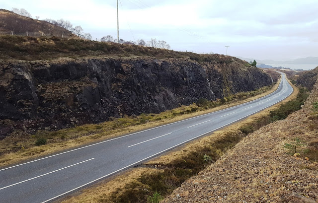
Near the highest part of the road leading from Tobermory to Salen, the area known as the Guala Dhubh, there are some impressive road cuttings which date back to when the road was upgraded. The rocks are all volcanic - Paeleogene lavas with prominent red boles in between many of them. On the west side of the road cut at Grid Ref NM 53306 51640, there is an obvious cleft in the rock - it shows up on Google Streetview as well.
I went to have a look at it some time ago but couldnt quite fathom it out - was it a dyke, a fault or maybe the cast of a fossil tree? I had been having some correspondence on Twitter with a PhD student who has been studying the Mull lavas and as a consequence of that I went back for another look. Pics and explanations below:


I went to have a look at it some time ago but couldnt quite fathom it out - was it a dyke, a fault or maybe the cast of a fossil tree? I had been having some correspondence on Twitter with a PhD student who has been studying the Mull lavas and as a consequence of that I went back for another look. Pics and explanations below:
The roadcut at the highest point of the Tobermory Salen road. Moira brought Geo-dog Daisy along to ensure that all was correct and in order.


The cleft is the obvious feature running up the cliff, seen from the other side of the road in this picture. Its got some ice in it

Much of the rock on the west side of the road was plastered in ice - not the best conditions for trying to work out the geology!
We walked down the top of ones side of the road cut and then came back up on the road itself
There are some good features to see in the rocks:

Many of the lava flows have an obvious red top to them. Generally considered to represent a period of sub-aerial weathering where a soil is produced in arid conditions. This would represent a long period of quiet activity between eruptions. Some researchers however have found evidence that some of these red layers may be pyroclastic in origin which would shorten the timescale considerably. Anyway, loads of these to be seen in Mull and these roadcuts have great examples on display

Amygdales! Lots of them. Gas bubbles filled with crystals. All sorts of good stuff to be seen here - a lot of the crystals are of calcite which is quite common. Have also found analcime and other zeolites and agate. ther are also many places where there are large gas cavities (vesicles) but no crystals lining them. Like Swiss cheese!
Finally, I got to the "feature" that I had come to look at:

This is it again, from the roadside. It doesnt appear to be a dyke. Whatever it is, it does not appear on the other side of the road (or maybe I didnt look hard enough!) Could it be a tree cast? The thing is, it runs across two lava flows - you can just about make out the red horizon between them, about half way up the photo. It seems unlikely that a tree would be swamped by one lava flow and then remain standing before another one hit it. Esp as there is a red layer in between which points at a gap in the eruption sequence. It looks like it might be a fault, although there is no vertical displacement on it - if there were, that red horizon would show such movement well. So the movement may be lateral - in and out of the photo if you like.
Heres another pic, a portrait format one:

There is a lot of ice in there as well.
I had a look at the top of the road cut on this side just to see what it looked like but there is very little to see - a tiny stream runs across and down it (hence the ice) but there are no obvious features to see. So I think it might be a small fault - but if someone can suggest something else, please let me know!
And the dog had a great walk!


Comments