In search of Loch Frisa Plugs - Brambles, Bracken and Brash
There are several volcanic plugs around North Mull, the most notable being 'S Airde Beinn. These plugs are reckoned to be conduits through which magma flowed, to pour out onto the surface as lava flows. There are two plugs marked on the BGS map near Loch Frisa at a location called An Sgriodain.
I had been to them before and was discussing them on Twitter just a few days ago. The weather was nice so it seemed a good place for an afternoon stroll.
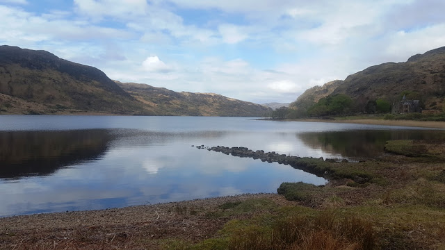
Loch Frisa looked impressive. Speinne Mor is the prominent hill in the distance.

Loch Frisa runs NW -SE like so much of the geographical features of Mull. Most of the dykes run in this direction as well, a reflection of the tectonic regime that was happening all these years ago during Palaeocene times.
The two plugs are not far from where the picture was taken. The first is high up on the hillside. Here is a picture from a few years ago - I didnt make it up there today as I was more interested in looking at the other one.
 This is what the upper plug looks like. Nice coarse dolerite - I had a section made of it - very crisp and clean under the microscope
And here is a close up showing the columnar jointing:

Looks like large columns on their side. Columns form at right angles to the cooling surface
Anyway, here is the lower plug from the Forestry road beside the loch.

Protected by a hideous barricade of brash, brambles, bracken and a bee or two, Seriously challenging walking to get to it. You can see the fallen trees clearly on the Bing map of the area!
Speaking of maps, the location of this site seems to be in a different place on the newer BGS map. The old map "Caliach Point" (1976) has it much closer to the road than on the newer map "North Mull and Ardnamurchan" (2010) However when I stood on top of the lower plug and checked the GPS, it was actually in a slightly different location again.
Started to wonder if I was actually on the right outcrop. But there is nothing else remotely like it nearby - it shows all the features mentioned in the Memoir.


The newer map has it (the green oD) further away from the loch compared to the old map.
Time to head back - it was just a short walk.
Here is a video clip from the top of the plug:
The Mull and Morvern plugs were well described in a paper by Andrew Kerr in 1997: Link below.
The geochemistry and significance of plugs intruding the Tertiary Mull-Morvern lava succession, western Scotland
I had been to them before and was discussing them on Twitter just a few days ago. The weather was nice so it seemed a good place for an afternoon stroll.
Loch Frisa looked impressive. Speinne Mor is the prominent hill in the distance.

Loch Frisa runs NW -SE like so much of the geographical features of Mull. Most of the dykes run in this direction as well, a reflection of the tectonic regime that was happening all these years ago during Palaeocene times.
The two plugs are not far from where the picture was taken. The first is high up on the hillside. Here is a picture from a few years ago - I didnt make it up there today as I was more interested in looking at the other one.

And here is a close up showing the columnar jointing:

Looks like large columns on their side. Columns form at right angles to the cooling surface
Anyway, here is the lower plug from the Forestry road beside the loch.

Protected by a hideous barricade of brash, brambles, bracken and a bee or two, Seriously challenging walking to get to it. You can see the fallen trees clearly on the Bing map of the area!
Speaking of maps, the location of this site seems to be in a different place on the newer BGS map. The old map "Caliach Point" (1976) has it much closer to the road than on the newer map "North Mull and Ardnamurchan" (2010) However when I stood on top of the lower plug and checked the GPS, it was actually in a slightly different location again.
Started to wonder if I was actually on the right outcrop. But there is nothing else remotely like it nearby - it shows all the features mentioned in the Memoir.


The newer map has it (the green oD) further away from the loch compared to the old map.
Time to head back - it was just a short walk.
Here is a video clip from the top of the plug:
The Mull and Morvern plugs were well described in a paper by Andrew Kerr in 1997: Link below.
The geochemistry and significance of plugs intruding the Tertiary Mull-Morvern lava succession, western Scotland


Comments