North Mull Mesozoic Rocks (4) Bloody Bay Sandstone Quarry
This mornings walk was to the old quarry at Bloody Bay, north of Tobermory. The rock from the quarry was used to build the approach to the Rubha nan Gall lighthouse a little further south. The rock is a nice red sandstone, slightly enigmatic. According to the BGS Map, North Mull and Ardnamurchan, 2013, the stratigraphic position of this rock isn't certain. The map carries this legend:

So it is possibly Jurassic.
There is a description in the Ardnamurchan and NW Mull Memoir:
"Prof Judd drew attention to a red sandstone quarried in the west cliff of Bloody Bay... The locality is about a quarter of a mile SE of Ardmore Farm and of easy access from above.....the eroded surface of the the sandstone is seen to be directly covered by the basaltic lavas.. The sandstone is of good quality and has been used in the wall of the path leading to Rubha nan Gall lighthouse. It is at least 50 ft thick, current bedded and red in colour with a small proportion of rounded grains. It also carries irregular concretionary bands of iron ore...The sandstone is comparable with the thick sandstone locally reddish which forms the upper part of the Inferior Oolite of Ardnamurchan"
So, here we go with some pics:
The Memoir refers to "easy access from above" Not at all sure about that one! The cliff is pretty steep and the forestry is thick. I found it easier to go round by Rubha na Sealbhaig where I was a few weeks ago - following the coast is quite a pleasant if rough walk anyway

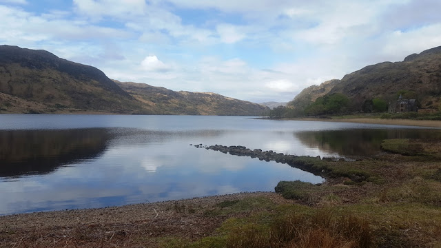
Looking over to Ardnamurchan from near Rubha na Sealbhaig


Some pics of the very prominent dyke at this headland. Mull Swarm Dyke, stands up like a wall. Can be seen from the sea. Apparently it is known as Bodach Ard More - the old man of Ardmore. A brilliant example of a Mull Swarm Dyke
Moving on to the south,

Bloody Bay up ahead - named after a sea battle. The sandstone quarry lies up the slopes about half way round.The walking is rough along the shore but not too bad.
I found this fragment of what is maybe a thin dyke. The tachylite margin is very obvious as well as a line of druses up the middle. No sign of it in situ however

The boulder is about 30 cm thick, with the black glassy tachylite margin on both sides
It was time to start the slog up to the quarry but first some views:


The wide expanse of the Bay looking over to Ardnamurchan. In the upper picture, you can just make out the lighthouse at Rubha nan Gall. Lower pic shows the CalMac ferry and Beinn Hiant
The slog up to the quarry is an absolute trudge of soft soil, huge amounts of bracken and brambles. Quite hard going. There is an obvious runnel down the hill slope - this is where the sandstone was taken down to the shore. Apparently there were rails and the blocks went down that way. no trace of this now of course, just an indentation in the hill slope

From the shore, looking up at the quarry - hard to see, but there is a vague line running down the slope - that is where the blocks were taken - the quarry is at the top of that
 In front of the quarry - the sandstone outcrop has a pointed shape - basically a paleo-hill, the basalt lavas poured over the top

 A couple of pictures to show the finer detail of the structures in the sandstone. Current bedding is obvious

Another view of the quarry - the light was catching it quite well. On previous occasions I have been here it has been dull - the rock looked much neater today
 Some of the concretions mentioned in the memoir

And a final view from the RHS - the pointed shape is quite obvious. There is quite a large hollow directly in front of the quarry face, presumably where rock was extracted.
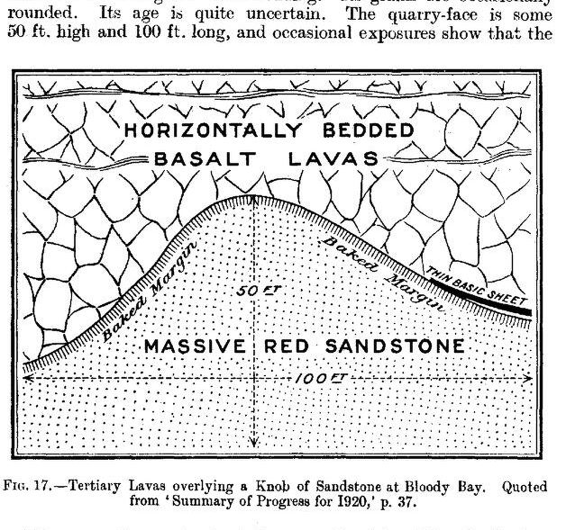
Here is a snip of the diagram in the Mull Memoir:
It was a case of heading back after that.I was tempted to try a walk up the slope towards the tree line but the bracken is unbelievably thick and nasty. Much easier going back along the coast. One final view over to Ardnamurchan
 Not a cloud in the sky
And one final picture from Rubha na Sealbaig

Good columnar basalt here - showed up well with the angle of the sunlight.
Just to finish, a couple of things that struck me.
1) The Memoir refers to Ardmore Farm, not the "ruins" of Ardmore Farm which is what you see today. Presumably the Farmhouse buildings were intact and or occupied at the time of the Survey. Need to find out
2) There is not a lot of information about the quarry to be found apart from what is given in the Memoirs. Would be interesting to find out more about it. I'll update this blog with more information if I can track it down

So it is possibly Jurassic.
There is a description in the Ardnamurchan and NW Mull Memoir:
"Prof Judd drew attention to a red sandstone quarried in the west cliff of Bloody Bay... The locality is about a quarter of a mile SE of Ardmore Farm and of easy access from above.....the eroded surface of the the sandstone is seen to be directly covered by the basaltic lavas.. The sandstone is of good quality and has been used in the wall of the path leading to Rubha nan Gall lighthouse. It is at least 50 ft thick, current bedded and red in colour with a small proportion of rounded grains. It also carries irregular concretionary bands of iron ore...The sandstone is comparable with the thick sandstone locally reddish which forms the upper part of the Inferior Oolite of Ardnamurchan"
So, here we go with some pics:
The Memoir refers to "easy access from above" Not at all sure about that one! The cliff is pretty steep and the forestry is thick. I found it easier to go round by Rubha na Sealbhaig where I was a few weeks ago - following the coast is quite a pleasant if rough walk anyway

Looking over to Ardnamurchan from near Rubha na Sealbhaig


Some pics of the very prominent dyke at this headland. Mull Swarm Dyke, stands up like a wall. Can be seen from the sea. Apparently it is known as Bodach Ard More - the old man of Ardmore. A brilliant example of a Mull Swarm Dyke
Moving on to the south,

Bloody Bay up ahead - named after a sea battle. The sandstone quarry lies up the slopes about half way round.The walking is rough along the shore but not too bad.
I found this fragment of what is maybe a thin dyke. The tachylite margin is very obvious as well as a line of druses up the middle. No sign of it in situ however

The boulder is about 30 cm thick, with the black glassy tachylite margin on both sides
It was time to start the slog up to the quarry but first some views:


The wide expanse of the Bay looking over to Ardnamurchan. In the upper picture, you can just make out the lighthouse at Rubha nan Gall. Lower pic shows the CalMac ferry and Beinn Hiant
The slog up to the quarry is an absolute trudge of soft soil, huge amounts of bracken and brambles. Quite hard going. There is an obvious runnel down the hill slope - this is where the sandstone was taken down to the shore. Apparently there were rails and the blocks went down that way. no trace of this now of course, just an indentation in the hill slope

From the shore, looking up at the quarry - hard to see, but there is a vague line running down the slope - that is where the blocks were taken - the quarry is at the top of that


Another view of the quarry - the light was catching it quite well. On previous occasions I have been here it has been dull - the rock looked much neater today


And a final view from the RHS - the pointed shape is quite obvious. There is quite a large hollow directly in front of the quarry face, presumably where rock was extracted.
Here is a snip of the diagram in the Mull Memoir:

It was a case of heading back after that.I was tempted to try a walk up the slope towards the tree line but the bracken is unbelievably thick and nasty. Much easier going back along the coast. One final view over to Ardnamurchan

And one final picture from Rubha na Sealbaig

Good columnar basalt here - showed up well with the angle of the sunlight.
Just to finish, a couple of things that struck me.
1) The Memoir refers to Ardmore Farm, not the "ruins" of Ardmore Farm which is what you see today. Presumably the Farmhouse buildings were intact and or occupied at the time of the Survey. Need to find out
2) There is not a lot of information about the quarry to be found apart from what is given in the Memoirs. Would be interesting to find out more about it. I'll update this blog with more information if I can track it down


Comments